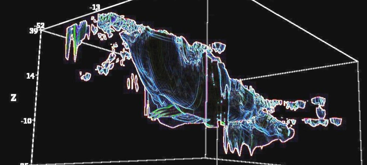
Tomographic image by John Larsen, reconstructed from on-site resistivity measurements, performed in 2014 by Ron Wyatt’s archeological team. In an earlier expedition (1986-1987), Ron Wyatt still used radar, which is much less sensitive for this application: the ship’s bottom is located 38 meter below ground level. The site is named after Turkish Captain Ilhan Durupınar, who identified it in 1959, on a photograph he took while on a NATO aerial mapping mission. He forwarded the photographic negative to an aerial photography expert, Dr. Arthur Brandenburger, at Ohio State University. Brandenburger was responsible for discovering the Cuban missile bases during the Kennedy era from reconnaissance photos, and after carefully studying the photo, he concluded: “I have no doubt at all, that this object is a ship. In my entire career, I have never seen an object like this on a stereo photo.”
In 1960, an American team of investigators visited the recently discovered Durupınar site. They reported nothing of any archeological interest. Arthur Brandenburger believed otherwise, and communicated his concerns to Ron Wyatt (1933–1999), anesthetist and self-educated biblical archaeologist from Madison, Tennessee. As Turkish authorities would not allow excavation, Ron asked his friends to pray for a local earthquake. The 1978 earthquake did what Ron had so much prayed for: it uncovered a ship impaled on a large outcropping of limestone. August 1979 followed the devastating news: the ship’s length was 515 feet, too long to fit the biblical reference! Ron showed, however, that the biblical cubits were not late Hebrew cubits, but early Egyptian ones, which were the standard in 2350 BC (Ron’s estimated age of the ship). The ship’s 515 feet closely fit 300 Egyptian cubits, which is precisely the size mentioned in Genesis 6:15. Biblical archeologists had long been looking for a shipwreck of 437 feet (equivalent to 300 Hebrew cubits), but never found anything remotely similar.
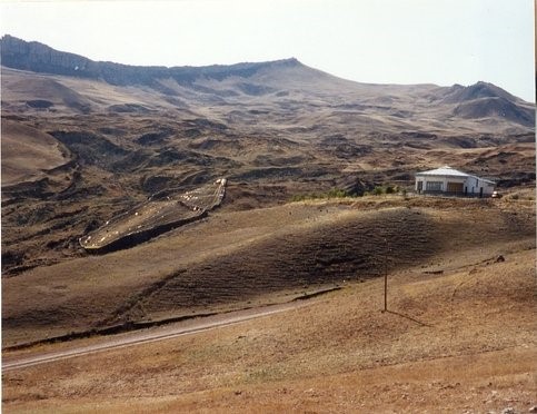
The Durupınar site is a large aggregate structure on Mount Tendürek in eastern Turkey, at an elevation of 2 km above sea level. The site is located 29 kilometers south of the Mount Ararat summit. |
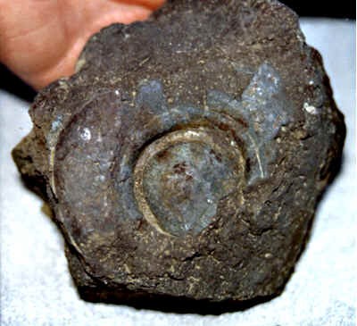
The earthquake laid bare deck joists and support timbers. Here an image of a fossilized rivet: it contains sizeable amounts (impossible to find in natural geology) of magnesium, titanium, iron, and aluminum. |
The ship was fossilized due to a lava eruption of a then active, now disappeared volcano. The structural terrain’s crescent shape, necessary for attracting a ship in the case of lowering sea levels, was found 1.5 miles higher up, together with what was left of the bottom of the ship, and an interesting stele, displaying (to the right) eight persons. The highlighted mountain top is no longer visible, whereas the range at the left hand side still stands.
Reconstructed stele, discovered some 1.5 miles mountain-upwards. Translating the location literally, the ship was found on “Doomsday Mountain” (Cesnakidag) in the “Village of the Eight”. The largest anchor (drogue) stones ever discovered are located there. ‘Anchor stones’ refer to the weights used on ships both to stabilize them, and to keep their prow directed towards the incoming waves.
Wyatt’s discovery provides an excellent storyline for a thriller. Three of his most faithful collaborators retracted: geophysicist John Baumgardner, who sank so low as to accuse Wyatt of planting evidence on the site; geologist Thomas Fenner, who took the Heavy Duty Subsurface Interface Radar data, and wrote a similarly strange retraction; and US Merchant officer/salvage expert Dave Fasold (1939–1998), who retracted his retraction. Fasold’s own 1988 book The Ark of Noah, published ten years before his death, leaves no doubt that the author was convinced of the veracity of his findings.
In 1984, Apollo-15 astronaut Col. Jim Irwin (1930–1991) sent a specimen of the above shown rivet to Los Alamos: they found (like the Turkish researchers, independently) that the sample contained sizeable amounts of magnesium, titanium, iron, and aluminum. The concentrations were so high that it can only be explained by metal casting. Baumgardner correctly qualified the sample as a tailing of aluminum alloy production. ‘Tailings’ consist of ground rock and process effluents that are generated in a mine processing plant. In a video, Baumgardner is shown, following the linear tracks with a metal detector, and commenting: “No doubt in my mind. This is a man-made structure, full of metal; the size and shape almost certainly indicate the presence of a large boat”. Later, Baumgardner retracted what was once doubtless in his mind. His mind got confused to the point of believing that Wyatt planted metal on the Durupınar site.
Is it possible, from a scientific point of view, that a few thousand years ago, a huge ship landed at the Durupınar site, which today is about 2 km above sea level? It is known that sea levels varied over several hundreds of meters in the geological past, but since the past 22.000 years (the last glacial episode), sea levels have been uniformly rising (over 120 meter: quite a lot, but still peanuts compared to 2 km). The Egyptian Sphinxes show traces of heavy water erosion. Minority archeologists like Robert M. Schoch, Colin Reader, and David Coxill, believe that the Sphinxes significantly predate the oldest Egyptian dynasties: only the Sphinxes’ heads (originally of lions) were carved by the Egyptian dynasties. This explains the much higher levels of (vertical) erosion of Sphinxes as compared to pyramids (which were built by the Egyptian pharaonic dynasties). The large majority of archeologists believes that Sphinxes were built by Egyptian dynasties, too, but fail to explain their erosion. Yet, even if the minority view were correct, rainfall cannot cause the sea level to rise 2 km. The only way to get a ship up there, is catastrophic plate tectonics, as first proposed by John Baumgardner. It is only too bad that Baumgardner is a young-earth creationist, for he is a brilliant scientist.
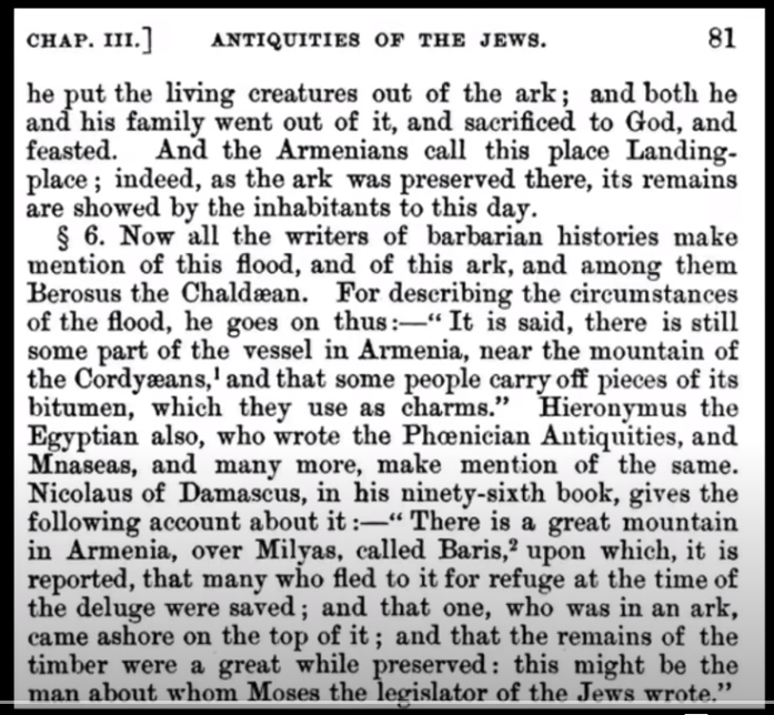
Ancient Jewish historian Flavius Josephus referred to the location in his Antiquities of the Jews. In chapter III, he mentions no only the location (the Armenian Milyas, Mount Baris, and the Cordyaeans), but also the many known historians of his time who wrote about Noah’s Ark.
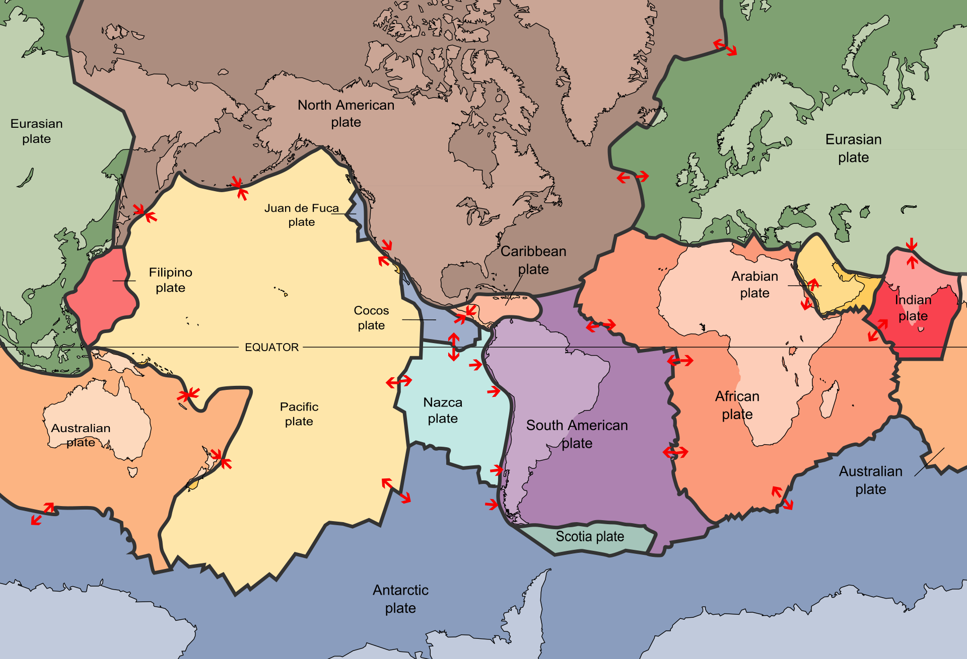
Tectonic plates. The volcano at mount Durupınar is located on the border between the Arabian and the Eurasian plates, at the northmost excursion. The Durupınar volcano that washed down the ship, and preserved it in its lava, might have formed after the ship touched ground. If the volcano had an elevation of 1.5 km with respect to the surroundings, one needs only 500 meter of water. A huge Tsunami might do the job. Notice, furthermore, that the same plate margin also runs through the gulf of Aqabah, where Moses crossed the ‘Sea of Reeds’.